


Key Findings
- Accra has flooded in the same communities, Odawna, Alajo, Kaneshie, Circle, Nima, Dansoman, and Weija, every rainy season since at least 2010. These are not random events; they are predictable failures.
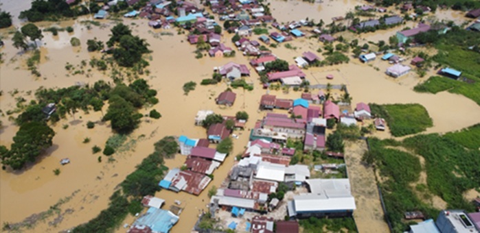
- The June 2026 rainy season delivered 333mm of rainfall, nearly four times the 85mm recorded in June 2024, and the June 29 storm alone dropped approximately 140mm in a single day, killing 12 people, displacing 7,761 households, and affecting 38,802 residents across Greater Accra.
- Approximately 71% of the Accra Metropolitan Area lies in medium-to-high flood-risk zones, and roughly 30% of the Greater Accra population is under permanent flood threat, yet flood infrastructure spending has delivered only 36% of committed funds after six years.
- The Odaw River, Accra’s primary stormwater channel, is heavily silted, choked with solid waste, and encroached upon by informal settlements. It is the single biggest infrastructure failure driving Accra’s worst floods.
- Flood losses in Ghana have exceeded US$1.7 billion over the past decade. For low-income residents in Accra’s hotspot communities, a single flood is not a seasonal inconvenience; it is a financial shock that erases years of household progress.
Why This Matters
Accra is a city of over five million people built across a landscape of natural drainage channels, wetlands, and coastal plains. For decades, those natural flood management systems have been built over, encroached upon, and choked with waste. The result is a capital city where even a significant rainfall event is now enough to trigger catastrophic flooding. Communities bearing the highest cost, Alajo, Nima, Agbogbloshie, Odawna, Dansoman, are low-income communities that cannot afford to keep absorbing these losses.
Every year, the government declares an emergency, responds, and moves on. Every year, the same communities flood. The data do not describe a natural disaster; they describe a preventable, recurring policy failure. Policymakers, the Accra Metropolitan Assembly, and drainage authorities need to act on what the data has already confirmed.
Detailed Analysis
| Finding 1: The Same Communities Flood Every Year Accra has experienced major flooding in 2010, 2015, 2016, 2022, 2023, 2025, and 2026, with the same communities consistently among the worst affected. The Greater Accra Regional Security Council (REGSEC) issued its official June 2026 flood-prone community list on June 10, 2026, and it reads almost identically to NADMO flood reports from a decade ago. The confirmed recurring hotspots include: Odawna and Official Town (Adabraka); Alajo, specifically the D.K. Poison and Polo Park areas; Berlin Bridge and Downside (Nima); Otojor (Dansoman); Jelil Estate Junction and Baba Yara Area (Madina); Osu Alata and Osu Doku; Abelemkpe; Kaneshie; Circle/Kwame Nkrumah Interchange; and Weija.The geographic footprint is expanding. Historically, flooding was confined to communities near the Odaw River. Today, the flood map covers virtually every major suburb from the Airport residential area to Legon, Lashibi-Klagon, Ofankor, Dzorwulu, and beyond. Each heavy storm claims a new area, signalling that Accra’s underlying infrastructure has been overwhelmed beyond its design capacity. |
| Finding 2: 2026 Has Been Accra’s Worst Flood Year in Recent Memory Meteorological data shared by President Mahama following an aerial inspection of flood-affected areas on June 29, 2026, confirms that June 2026 recorded approximately 333mm of total rainfall compared with 172mm in June 2025 and 85mm in June 2024. Rain fell for approximately 22 days in June 2026 alone, giving Accra’s drainage systems almost no recovery time between storms. When a single 140mm downpour hit on June 29, the city’s already-saturated infrastructure had no capacity left.The human cost was confirmed by Interior Minister Mohammed Muntaka Mubarak in Parliament: 12 deaths, 7,761 households displaced, and 38,802 people affected by the June 29 event alone. A body was found in floodwater at Tetegu on June 14, 2026. Four people died, including a child swept into a gutter, in a May 2025 event that dropped 132.2mm in just three hours in Nima. In 2023, researchers recorded approximately 20 separate flooding incidents across Greater Accra, the highest frequency in recent memory. |
| Finding 3: The Odaw River Is Accra’s Most Critical Infrastructure FailureThe Odaw River and its tributaries, the Nima, Onyasia, Dakobi, and Ado streams, drain most of Accra’s built-up areas. Almost 60% of Greater Accra Region residents live within the Odaw River basin catchment. The river is designed to carry stormwater from the city’s northern catchment to the Korle Lagoon and out to sea. Instead, it is heavily silted, obstructed by plastic waste and informal settlements, and narrowed by structures built directly on its banks. During heavy rains, it overflows, flooding Alajo, Nima, parts of the central business district, and surrounding communities.A 2024 hydrological study published in GeoHazards identified 5,018 landscape sinks in 23% of the Greater Accra Metropolitan Area and found 163 flood-induced roadblocks with depths exceeding 0.3 m, enough to render roads impassable to normal vehicles. Scientific modelling indicates that about 71% of the Accra Metropolitan Area’s total area falls within medium-to-high flood susceptibility classifications. A 2024 engineering assessment calculated that an enhanced Odaw flood-protection system capable of withstanding a one-in-25-year rainfall event would cost approximately US$675 million, more than triple the original GARID project budget. |
| Finding 4: Three Structural Drivers and None of Them Are RainAcademic research and independent engineering assessments consistently identify three structural drivers behind Accra’s flooding. Poor surface water management and choked drainage infrastructure; uncontrolled urban development on floodplains, wetlands, and waterways; and the compounding effects of climate change. Rain is the trigger, not the cause. Accra sits on a coastal plain that was once drained naturally by river basins and a network of lagoons, including the Korle, Sakumo, and Kpeshie. Wetlands that once absorbed enormous volumes of stormwater have been filled and developed. Stream channels have been narrowed by construction. Drainage systems are chronically blocked with solid waste because Accra runs a simultaneous waste management crisis that feeds directly into its flooding crisis.The climate dimension is worsening. Ghana’s rainfall is becoming more intense and compressed, the same annual volume arriving in shorter, more violent bursts. Research covering Ghana’s rainfall patterns from 1992 to 2022 shows that years with heavy early-season rains are reliable predictors of severe flood seasons. Under moderate climate scenarios (SSP2/SSP3), flood susceptibility zones in Greater Accra are projected to expand further between now and 2050. |
| Finding 5: The Economic Cost Is No Longer SustainableCumulative flood-related losses in Ghana have exceeded US$1.7 billion over the past decade (World Bank, 2021; Asamoah, 2023). Flood events routinely affect more than 110,000 households nationwide. For Accra specifically, the 2015 June 3 disaster, which killed over 150 people, affected approximately 53,000 people. The World Bank committed US$150 million under the Greater Accra Resilient and Integrated Development (GARID) Project to improve flood management and drainage across the Odaw basin for 2.5 million residents. As of mid-2025, approximately US$127.1 million or 36% of the total, had been disbursed after six years. The Odaw basin remains heavily encroached, and at-risk communities have received no meaningful relocation support.For the traders at Kaneshie and Makola markets, for the families in Alajo and Nima, the economic shock of each flood is not covered by insurance, not compensated by the government, and not recoverable in days. Less than 5% of disaster losses in developing countries are insured. Every flood season, the city pays in lives, household savings, productivity, and emergency response for infrastructure that has been underfunded and mismanaged for decades. |
Recommendations
AMA / Ministry of Works and Housing: Immediately operationalise a permanent, year-round Odaw River dredging and de-silting programme with a dedicated maintenance budget and published quarterly progress reports. The Odaw is the single biggest infrastructure lever in Accra’s flood control system. Seasonal exercises are insufficient.
Ministry of Lands and Natural Resources / AMA: Enforce a hard moratorium on construction within 30 metres of the Odaw River, its tributaries, and all identified wetland zones. Existing encroachments in the highest-risk zones must be assessed, with a published resettlement plan and timeline for affected communities.
Ministry of Finance / NADMO: Activate Ghana’s parametric flood insurance framework, developed in collaboration with UNDP, for all communities formally designated as flood hotspots by REGSEC. This would provide automatic, rapid payouts when rainfall thresholds are breached, reducing the time between disaster and household recovery from months to days.
Ministry of Sanitation / AMA: Fix the waste management crisis feeding the drainage crisis. Plastic waste and silt account for a significant share of all drainage blockages. A functional household waste collection system in flood-prone communities is not a sanitation issue; it is a flood control intervention.
Parliament / Ministry of Works and Housing: Demand a public accounting of GARID project spending. After six years and US$127.1 million in disbursements, the Odaw basin remains heavily encroached upon, and communities continue to be flooded. Parliament should require quarterly performance reporting against measurable flood-risk reduction targets, not just construction milestones.
Methodology Snapshot
This brief is a Rapid Research publication drawing on publicly available official records, peer-reviewed academic literature, and verified news reporting. Primary data sources include: REGSEC official flood-prone community statement (June 10, 2026); Interior Minister Mohammed Muntaka Mubarak’s parliamentary disclosure on June 2026 flood casualties; Ghana Meteorological Agency (GMet); President Mahama’s aerial inspection data (June 29, 2026); NADMO flood incident records; the World Bank GARID project documentation; and peer-reviewed studies published in GeoHazards (2024), ScienceDirect (2023), Frontiers in Sustainable Cities (2024), and Scientific Reports (2026). Economic loss figures draw on World Bank (2021) and Asamoah (2023) estimates compiled in ModernGhana (2026). The analysis covers the period 2010–2026, with a primary focus on events in 2023–2026.
Limitations
- This is a Rapid Research brief. It synthesises existing data; it does not present primary survey data or new field measurements.
- NADMO does not publish standardized, disaggregated incident data by community. Hotspot identification draws on official statements, academic mapping, and verified news reporting rather than a single authoritative NADMO database.
- Economic loss estimates ($1.7bn over a decade) are national figures. Community-level economic damage data for Accra, specifically, is not systematically collected or published.
- Rainfall data referenced from June 2026 draws on figures released by President Mahama post-aerial inspection. GMet’s full station-level data for 2026 was not available at the time of publication.
- This brief covers Greater Accra. Flood dynamics in other Ghanaian cities are not addressed here.
Sources / References
1. Greater Accra REGSEC Official Statement, June 10, 2026 – Regional Minister Linda Obenewaa Akweley Ocloo. Reported by Graphic Online, Pulse Ghana, Adom Online, Asaase Radio.
2. Interior Minister Mohammed Muntaka Mubarak, Parliamentary Disclosure on June 2026 Flood Impact. GBC Ghana Online, June/July 2026.
3. ViewGhana: Accra Floods 2026: Areas Affected, Causes & What Really Happened. June 30, 2026. viewghana.com
4. UNDP Ghana: ‘Accra Under Water Again.’ June 2026. undp.org/ghana
5. MyJoyOnline: ‘Accra under water, again: Inside Ghana’s 66-year flooding crisis that nobody has fixed.’ June 2026. myjoyonline.com
6. ModernGhana: ‘Flooding in Ghana’s Major Cities: Why Accra Continues to Drown and What Must Change.’ June 29, 2026. modernghana.com
7. Africa.com: ‘Ghana’s capital Accra Submerged As Floods Expose Long-running Urban Drainage Crisis.’ June 29, 2026. africa.com
8. Møller-Jensen, L. et al. (2024). ‘The Identification of Flood-Prone Areas in Accra, Ghana Using a Hydrological Screening Method.’ GeoHazards, 5(3), 755-779.
9. Forson, E.D. et al. (2023). ‘Geophysical assessment of flood vulnerability of Accra Metropolitan Area, Ghana.’ ScienceDirect.
10. Frontiers in Sustainable Cities (2024). ‘Flood risk reduction and resilient city growth in sub-Saharan Africa: searching for coherence in Accra’s urban planning.’
11. Scientific Reports (2026). ‘Rising urban flood risk and exposure under shared socioeconomic pathways in Greater Accra Ghana.’ Nature.
12. World Bank GARID Project Documentation, 2019-2025. worldbank.org
13. Amoako, C. & Boamah, F. (2015). ‘The three-dimensional causes of flooding in Accra, Ghana.’ International Journal of Urban and Regional Research.
14. GhanaWeb: ‘Here are areas badly hit by Accra floods after heavy rains.’ June 29, 2026. ghanaweb.com
15. Pulse Ghana: ‘NADMO issues flood alert for 3 major areas.’ June 29, 2026. pulse.com.gh
16. NADMO Flood Disaster Profile – Ghana. nadmo.gov.gh
17. Asamoah, E. (2023). Flood loss estimates for Ghana, cited in ModernGhana (2026).
18. Ministry of Works and Housing (2019). Population at flood risk estimates. Cited in ScienceDirect (2023).